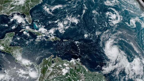
Hurricane Lee: Forecasters warn it could be ‘extremely dangerous’ with winds of more than 150mph

Tropical Storm Lee has strengthened into a category 1 hurricane – and could become “extremely dangerous” over the weekend as it heads towards islands in the Caribbean.
Lee is not expected to make landfall on a path forecasters believe will take it near the northeast of the region.
But the storm is expected to cause swells – powerful waves in the ocean – with Puerto Rico and the British and US Virgin Islands particularly under threat.
According to the National Hurricane Center (NHC), winds were whipping around at 80mph on Thursday and “could increase quickly”, with forecasters warning winds could top 150mph.
By Saturday it is forecast to peak as a major hurricane, which is defined as a storm with winds of at least 111mph – category 3.
“It has the potential to become a powerhouse category 5 hurricane, the strongest hurricane of the year,” said Jonathan Porter, chief meteorologist for AccuWeather.
The hurricane is expected to generate life-threatening swells, with the seas around Puerto Rico potentially rising up to more than 3m (12ft), according to the National Weather Service in the capital San Juan.
The British Virgin Islands, meanwhile, is still recovering from hurricanes Maria and Irma in September 2017.
There is “increasing confidence” that the eye of the storm will not make landfall and will instead pass northwards beyond Puerto Rico.
The NHC warns there is still a 25% chance of Puerto Rico and nearby islands – including Bermuda and the Bahamas – experiencing “sustained tropical-storm-force winds.”
Twitter This content is provided by Twitter, which may be using cookies and other technologies. To show you this content, we need your permission to use cookies. You can use the buttons below to amend your preferences to enable Twitter cookies or to allow those cookies just once. You can change your settings at any time via the Privacy Options. Unfortunately we have been unable to verify if you have consented to Twitter cookies. To view this content you can use the button below to allow Twitter cookies for this session only. Enable Cookies Allow Cookies Once
“The environment around the cyclone looks ideal for rapid intensification,” the NHC said.
“The models are in fairly good agreement that significant strengthening should begin later today and continue into the weekend, when Lee will likely reach its peak intensity.
“Fluctuations in strength are likely from days three to five due to potential eyewall replacements, but Lee is still expected to be a dangerous hurricane over the southwestern Atlantic early next week.”
What do the categories mean?
Category 1 – very dangerous winds of up to 95mph that could cause some damage. Large branches could snap and smaller trees could be uprooted, while power outages are also possible.
Category 2 – winds are considered extremely dangerous and can blow up to 110mph. Houses could be badly damaged and power cuts should be expected.
Category 3 – devastating damage is expected, as hurricanes are now defined as major and winds reach up to 129mph. Many trees could fall and areas could be without power for days or even weeks.
Category 4 – much or the impacted areas could be uninhabitable for weeks as catastrophic damage occurs. Winds reach up to 156mph as fallen trees will block roads and isolate residential areas.
Category 5 – as winds top 157mph, power outages could last for months and there is a high chance homes will be destroyed.
Storms could get worse
The National Ocean and Atmospheric Administration warned in August this year’s season would see a higher number of storms than usual.
Between 14 to 21 named storms are forecast, with six to 11 of those potentially becoming hurricanes and up to five of them even becoming major hurricanes.
AccuWeather has also revised forecasts to predict three to five major hurricanes this season, compared with one to three in its previous analysis.
