UK heatwave: What is an omega block – and how is it causing our extreme weather?

An omega block is responsible for the heatwave which is gripping parts of the UK.
Here, we take a look at the weather pattern – and whether climate change could make it a more frequent feature in the years to come.
What is an omega block – and how does it get its name?
Blocks can interrupt the normal eastward progression of our weather.
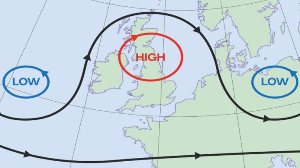
With an omega block, high pressure – which generally brings warmer and more settled conditions – becomes sandwiched between two low pressure systems.
It forms a shape like the Greek letter Ω, hence its name.
How does the omega block impact the jet stream?
Weather systems usually move from west to east at our latitude, but sometimes they can get blocked when the jet stream weakens and buckles.
The jet stream is a core of strong winds high above the Earth’s surface which helps to develop and steer areas of low pressure around the globe.
When there is a lot of tropical storm activity in the North Atlantic, this can bend the jet stream, which is what has happened on this occasion.
The position and strength of the jet has resulted in a blocking pattern where the high pressure becomes stuck between the two low pressure systems.

How long can such a block pattern last?
Weather blocks can persist for days, weeks, or even months.
One famous example was in the summer of 1976, when temperatures of above 30C brought drought conditions and persisted for long periods.
How is the block impacting the UK and Europe’s weather?
High pressure just to the east of the UK and centred over Scandinavia is allowing a feed of hot and humid air from the south.
We’re certainly feeling the effects, with Saturday now likely to be the hottest day of 2023 so far.
The Met Office is now forecasting a potential peak temperature of 33C in London at the weekend. The previous record for the year so far was 32.2C back in June.
The UK Health Security Agency (UKHSA) has issued an amber heat-health alert until 9pm on Sunday, which means the NHS is likely to be under extra pressure. The over-65s will be particularly vulnerable.
Met Office chief meteorologist Neil Armstrong said: “An active tropical cyclone season in the North Atlantic has helped to amplify the pattern across the North Atlantic, pushing the jet stream well to the north of the UK, allowing some very warm air to be drawn north.
“It’s a marked contrast to much of the meteorological summer, when the UK was on the northern side of the jet stream with cooler air and more unsettled weather.”
However, low pressure areas are affecting either side of the Mediterranean, with the remnants of Hurricane Franklin to the west of Portugal and Storm Daniel bringing torrential downpours to Greece.
Temperatures of above 30C (86F) in September have only happened a “handful of times” in the UK.
Forecasters say it is likely temperatures will remain over 20C (68F) at night in many areas.
Conditions are set to change a little – with thundery downpours slowly moving in from the west later on Wednesday – but the heat isn’t going anywhere for a while.
Is climate change making these heat domes more frequent?
Sky weather producer Kirsty McCabe said there is increasing evidence the jet stream is being weakened by climate change.
She said: “Blocked weather patterns such as omega blocks or heat domes seem to be happening more frequently in recent decades, and that could be linked to the effects of climate change on the jet stream.
“There is some research that suggests the jet stream is weakening due to a reduction in the temperature contrast between the equator to the pole as the Arctic has warmed at roughly twice the rate as the entire globe – scientists refer to this as ‘Arctic amplification’.”

What are the risks of such a heat dome?
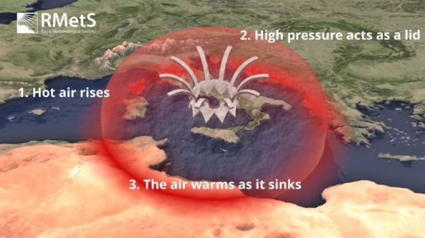
A stubborn area of high pressure means already warm or hot air trapped under the high will continue to become hotter, creating a heat dome.
Kirsty added: “Hot air will rise into the atmosphere, but high pressure acts as a lid and causes the air to subside or sink. As the air sinks, it warms by compression, and the heat builds.
“The ground also warms, losing moisture and making it easier to heat even more.
“Until the pressure pattern changes, the high will continue to exacerbate the hot conditions, bringing a risk of wildfires, drought and heat-health issues.”

Are there any other common block patterns?
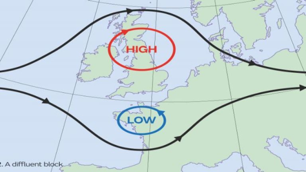
The Met Office says there is also a diffluent block along with omega.
Diffluent happens when there is a “split in the eastwards flow” – and can see high pressure pushed to the north of a low centre in the south, bringing prolonged periods of similar weather.
